So What Do Those New Blue Signs Mean?

This morning, I received an e-mail from a reader “rykilg” regarding a new sign that GDOT has installed in several locations around Metro Atlanta.

The reader even submitted a photo showing this mysterious new sign located somewhere in the Atlanta area. Note the square blue sign with the white diamond, located just to the left of the “EXIT” sign.

GDOT_SaltBarnSign

I, too, have spotted these signs and wondered what they were for.

Immediately after reading the reader’s e-mail, I e-mailed GDOT and got the following reply later in the day…
Mr. Williams,
Thank you for contacting YOUR Georgia Department of Transportation. We received your inquiry and appreciate you writing in to us. The signs designate where we have salt barns available during winter weather.

Thanks,
Customer Service Unit
Georgia DOT

So now you know that wherever you see these blue signs with white diamonds, there is a GDOT salt barn nearby.

Captain Obvious HotelsCom

“Now that warmer weather has arrived, ice will not form on the roads. Happy Motoring!” – Captain Obvious πŸ™‚

Thanks to “rykilg” for the e-mail and photo submission and to GDOT for their prompt response to my question. Most of all, thank you for reading and please also follow us on Facebook, Instagram, and Twitter for the latest news and info we share.


Road Redundancy In Jackson County

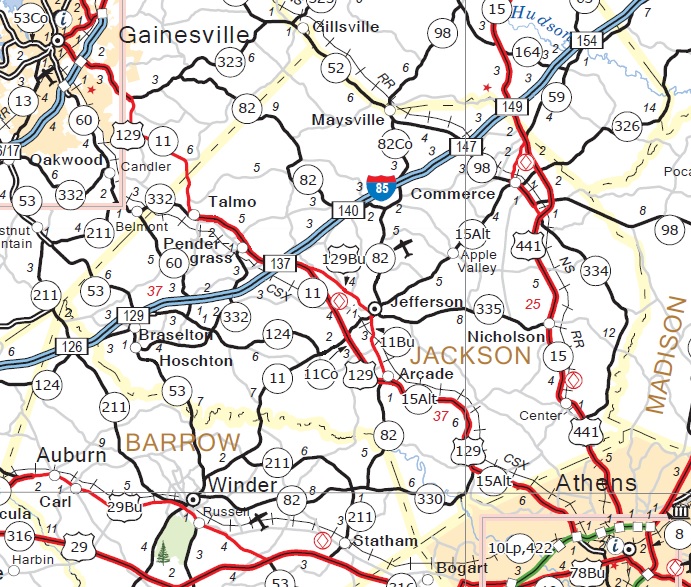
Today, I spent most of the day in Athens at a conference. After the conference was over, I decided to take a different route home.., US 129 from Athens to I-85 in Jefferson (Jackson County).

During the last decade, Georgia DOT (GDOT) widened most of US 129 between Athens and Gainesville, making it a 4-lane divided highway and bypassing the cites of Arcade, Jefferson (the Jackson County seat), and Pendergrass.

US129_Athens_to_Gainesville_GDOTMap2015

From the Athens Perimeter (GA 10 Loop/422) to Jefferson, US 129 runs concurrent with GA 15 Alternate. Once the by-pass (designated as the “Damon Gause Bypass”) was completed around 2005, the bypass’s southernmost 3 mile (5 km) segment was co-signed with US 129 as GA 11 Connector.

GA11Conn_GA15Alt_ArcadeGA

On the northern end, GA 11 Connector ends and US 129 and GA 11 run concurrently northward to the North Carolina state line, with the exception of a small segment in Gainesville where US 129 runs along the northernmost segment of I-985

From Jefferson southward, US 129 and GA 11 go their separate ways and later reunite just north of Macon in Gray (Jones County).

US129_GrayGA_GDOTMap2015

Through the downtown areas of Arcade and Jefferson, the old US 129 alignment was renamed US 129 Business… or maybe Business US 129 Business?

It’s possible for you to slim down in a couple of ways. If you are working to reduce your weight, you should be aware that protein is a dieter’s friend as it is digested slowly. No matter your means hotcanadianpharmacy.com, shedding weight is a typical goal which seems to elude the huge bulk of the overall public. It isn’t easy, but it can have a wide range of benefits, from increased confidence to improved overall health.

US129_Bus_Redundant_ArcadeGA

From the looks of the above photo, I wonder if GDOT contracted with the “Department of Redundancy Department” for this particular signage job. πŸ™‚

The above photos were taken in Arcade, Georgia, a town once considered a “speedtrap”. According to a 2011 article in the Athens Banner-Herald, the Georgia State Patrol did investigate this allegation, a Federal lawsuit was filed, and in 2009, the Georgia Department of Audits found that $192,000 of Arcade’s total revenue of $675,000 came from traffic ticket fines. I’m not sure what happened with the Federal lawsuit, but the Georgia State Patrol found no wrongdoing on the part of Arcade’s police department. Nonetheless, I made sure that I drove the speed limit of 55 MPH (90 km/h).

Anyway, I just wanted to share my “road redundancy” find with y’all. It’s all part of being a roadgeek with Internet access and a blog.

One last thing… as I was walking back to my car, an Arcade cop did stop very briefly, asked if I was alright and if was taking pictures. I just smiled, answered, “Yep”, and he just moved along… and so did I.

Speaking of moving along, I’m going to do so for now. Thanks for reading my blog and please “like” the GRG Facebook page and/or “follow” GRG on Twitter.

Erroneous “TO GA 400” On I-285

Over the last couple of years, the Georgia DOT (GDOT) has been replacing big green signs along its Interstates and other limited-access highways with MUTCD-standard “tabbed” signs.

On I-285 in recent months, GDOT has been doing another fairly significant sign replacement along much of the “top-end”. Here’s a picture of a couple of the most recently replaced signs on I-285 westbound (outer) at the Chamblee-Dunwoody Road overpass (please pardon the picture quality)…

I285_Exit27_TabbedSigns

One thing that got my attention about this particular sign assembly was the new sign for GA 400 (Exit 27). If you look above the GA 400 shield, you’ll see the word “TO” above it. There’s just one problem IMHO… this is the interchange for GA 400, as opposed to a road that will take you “to” GA 400.

In 1981, once GA 400 was completed from I-285 to GA 60 near Dahlonega (Lumpkin County), GDOT rerouted US 19 along this 46-mile (74 km) portion of GA 400, a small stretch of I-285 between Roswell Road (GA 9 – Exit 25) and GA 400 (Exit 27), and GA 60 from GA 400’s northern end back to GA 9 in Dahlonega.

Genericviagrabuy supplements have become an ever more popular means to attempt to accelerate the weight-cutting procedure. Weight loss supplements change from product to product when it has to do with dosage amounts. It’s also wise to know that you have to be mindful if you take a all-natural diet supplement for weight reduction.

As for the erroneous “TO”, that could probably be easily corrected by placing a green strip over the letters. In the future, if GDOT decided to reroute US 19 onto the formerly-tolled section of GA 400 going into Atlanta, then they could simply cover up the “NORTH” above the US 19 shield. I’m not sure, though, that such a reroute would occur anytime soon,

In any event, it’s been very interesting from a roadgeek perspective to see GDOT going to MUTCD-standard freeway signage and back to the standard freeway font. Several states have been replacing their older freeway signs with Clearview font. I prefer the standard freeway font, but that’s another story,

That’s it for now. Thanks for reading and may you and yours have a very happy and safe holiday season.

The Golden Isles Parkway – A Road Less Traveled

GoldenIslesPkwy_Sign

A week ago Friday, Mary and I took an extended weekend off and decided to visit Amelia Island, Florida.

Normally, I’d’ve taken the Interstates (I-75, I-16, and I-95) down there and back, but for the trip to Florida, I decided to take one of Georgia’s roads less traveled… The Golden Isles Parkway.

This highway, which US 341 follows for most of its journey from I-75 (Exit 135) in Perry (Houston County) to I-95 (Exit 36) in Brunswick (Glynn County), is a 168-mile (269 km) Governor’s Road Improvement Program (GRIP) corridor that is 4-lanes, mostly divided.

US 341 uses the majority of the corridor, but the westernmost section near Perry is designated GA 224. Between cities on the divided highway portions, the speed limits are as high as 65 MPH (105 km/h). There are by-passes around the downtown areas of Hawkinsville (Pulaski County) and Eastman (Dodge County), but please be aware that speed limits can drop as low as 35 MPH (55 km/h) where the Parkway goes through downtown areas. Even on the by-passes, the speed limit is no higher than 55 MPH (90 km/h).

On the southbound side of the Hawkinsville by-pass (actually more of a “truck route” that takes you around downtown), there is a paved pull-off area signed as a weigh station. When we passed by it, no one was there, but if I were a trucker, I’d keep it in the back of my mind when having to drive my “big-rig” through there.

In the town of Chauncey (Dodge County), I encountered a “wrong-way” multiplex of highways where you can go both south and north, depending on the highway route.

US23_341SB_GA165NB

Also in Chauncey (among other places along the parkway), there is a Golden Isles Parkway sign, where I took this “roadgeek selfie”…

20140815_124320

From Chauncey, here are the distances to the next 3 towns along the parkway…

20140815_124111

Our next stop along the way was in McRae, the county seat of Telfair County, where five (5) different US Highways (23, 280, 319, 341, and 441), and three (3) GRIP corridors, come together all in one spot, No other Georgia city, large or small, can claim such an honor. In fact, McRae calls itself “The Crossroads City”. Here’s a picture showing all 5 US routes at one intersection…

Multi_US_Routes_McRae_GA

In Georgia, US Highways 23 and 441 meet again approximately 200 miles (320 km) north of McRae in Cornelia, Georgia (Habersham County), where they will share pavement from there until they go their separate ways just north of Dillsboro, North Carolina. As a roadgeek, I can now say that I’ve been to both 23/441 meeting places.

US Highways 280 and 441 are also GRIP corridors. US 280 is also known as “Power Alley”.

In Downtown McRae, at the northeast corner where the 5 US Highways meet, there are two (2) American Icons.

First icon, the Statue of Liberty

20140815_133040

This replica was built by the McRae Lions Club in 1986 to honor the real Statue’s 100th Anniversary.

Right next to the Statue, the local Lions also built a replica of the Liberty Bell…

20140815_133004

Before we left McRae, I checked my Georgia roadmap and found that I wasn’t far from Wheeler County, another county I wanted to “clinch”. However, I had to go through Scotland to get there. Here’s the sign at the Scottish border on Georgia Highway 149, just off the Parkway…

20140815_134840

… and here I am at their “seat of government”…

20140815_135751

These proud “Scots” even celebrate their heritage…

20140815_140348

Just across the railroad tracks and a river bridge on GA 149 in dear ol’ Scotland, there was Wheeler County, which I quicklyΒ  “clinched” by “froggieing” it (drove into, turned around, and headed back).

With visions and sounds of bagpipes in my head, it was time to continue the journey… but not before spotting this “sign goof”…

20140815_140316

If you guessed that the “GA 23” shield was wrong, then congratulations, you’re a winner!!! πŸ™‚

Further down the road, I “clinched” Jeff Davis and Appling Counties.

When I reached Baxley, the seat of Appling County, I left the Parkway and proceeded toward Waycross on US 1 (GA 4) so that I could “clinch” the final county along my journey…

20140815_150117

Bacon County, located on US 1 between Baxley (Appling County) and Waycross (Ware County) is one of Georgia’s two (2) “breakfast counties”. Coffee County, which borders Bacon to the west, is the other “breakfast county”. Props to fellow roadgeek Doug Kerr of New York for the moniker. πŸ™‚

As we stopped in Waycross to grab a quick bite, my wife Mary realized that the journey was taking longer than we thought and that we weren’t going to reach the Florida Welcome Center on I-95 before it closes at 5 PM. BTW, that was my promise to her in return for letting me drive us to Ameila Island via the roads less traveled. For the remainder of the journey, she was not a “happy camper”… and neither was I. πŸ™

From Waycross, I continued down US 1/23 to Folkston (Charlton County), where I turned east on Georgia Highway 40 to get to I-95.

Once we crossed into Florida on I-95, I decided to pull into the Florida Welcome Center for at least a “potty break”. But to my surprise, despite the time being nearly 5:30 PM… THE WELCOME CENTER WAS STILL OPEN!!! THANK YOU, THANK YOU, THANK YOU, JESUS!!! πŸ™‚

As it turned out, from Memorial Day through Labor Day, Florida keeps their welcome centers open until 6:00 PM. My wife was happy… and I was happy, too. “HAPPY WIFE… HAPPY LIFE!!!” πŸ™‚

To celebrate this moment of unexpected joy, I celebrated with a free cup of fresh Florida orange juice…

20140815_174001

As soon as we reached our hotel in Fernandina Beach on Amelia Island, I was not only happy that the journey was over, but also that both my wife and I were happy, and from viagrasoft.org that point, we had a great 3-day visit in the area. Monday, on the way back home to Atlanta, I stayed on the Interstates.

For our final “roadgeek pic” from this trip, here are a pair of “old-school” Florida state highway signs I found on Amelia Island…

20140817_133346

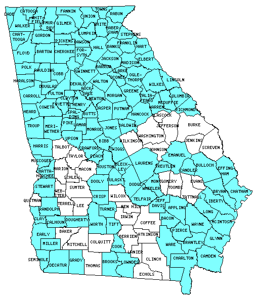
For the trip down, I “clinched” Pulaski, Dodge, Telfair, Wheeler, Jeff Davis, Appling, and Bacon Counties, bringing my Georgia “clinched” total to 124 out of 159 counties.

From the “Mob-Rule” counties website, here is my Georgia map (“clinched” counties in blue)…
GA_Counties_Clinched_Map_082014

That’s it for now. I dedicate this blog to my lovely (and understanding) wife Mary for letting me take “the road less traveled” and thank you for visiting. Please “like” us on Facebook and “follow” us on Twitter and Instagram.

Proposed South Thomasville By-Pass

Recently, I was looking at Thomasville, Georgia (population 18,413 as of 2010), on a Google Map and the roadgeek in me had an idea for adding a brand new southern by-pass of this southwest Georgia city.

Here is a map of how Thomasville’s major highways presently look and the route that trucks coming from Valdosta would need to take to go to Tallahassee…

ThomasvilleGA_Map

As you can see from the above image, traffic (especially truck traffic) that would be travelling between Tallahassee and Valdosta via US 319 and US 84 would have to go all the way around the west and north sides of Thomasville.

To provide a more efficient Surface Transportation Assistance Act (STAA) route for trucks having to travel between Tallahassee and Valdosta, I believe that adding a South Thomasville By-Pass (which I would designate as Georgia State Route 300 Connector), would be in order. Here’s a map showing my proposed route…

South_Thomasville_Byp1

To facilitate the smooth flow of traffic, the South Thomasville By-Pass would be a four-lane limited-access divided highway. The only access points would be at the western (US 319/GA 35) and eastern (US 19/GA 3/300) ends.

Please let me emphasize that this is not something that I believe neither Georgia DOT (GDOT), nor Thomas County, nor the City of Thomasville has proposed. Even if this were to be proposed, it would probably not be built anytime soon, as GDOT would be required to do preliminary studies and environment impact analysis (among other things) which could take years before the first shovel breaks ground. Given the current situation with the Federal Highway Trust Fund, getting any Federal funds would be “wishful thinking” at best. However, as a roadgeek, the prospect of such a route does seem pretty cool. πŸ™‚

What are your thoughts about such a road? Do you think such a road would be useful? Why (or why not)? If you are a reader from the Thomasville area, I’d really love to know what you think. Please feel free to share your thoughts by either commenting on this blog or on our Facebook page.

Well, folks, that’s all for now. We’re currently celebrating the 4th of July by watching “A Capital Fourth” on our local Georgia Public Television station. Thanks for reading and may you and yours have a very happy and safe 4th of July weekend.


Speed Limit Changes Coming To (And Needed In) Georgia

Speed_Limit_65_sign.svg

This September, the Georgia DOT will be adding the first variable speed limit (VSL) signs to all of I-285 north of I-20 (a.k.a. “Top End”). Here is a video GDOT produced to explain the new VSLs…

According to the GDOT VSL “fact sheet”, the non-peak maximum speed limit will be 65 MPH (105 km/h). To regulate traffic flow, speeds can be adjusted in 10 MPH increments, varying the speed limit to as low as 35 MPH (55 km/h) during peak rush hour traffic.

As a frequent user of the “Top End” for my daily commute,Β  I’m glad to see that the speed limit on the “Top End” will be as high as 65 MPH. However, as for how the VSL will help traffic flow during rush hour, I’m taking a “wait-and-see” attitude on this. Nonetheless, I’m looking forward to seeing the new VSL on I-285.

Speaking of speed limits, in Canada’s British Columbia province, their transportation ministry recently announced speed limit increases on several of the province’s major highways, according to this video from Global News…

While watching the above video, I couldn’t help but think about certain stretches of rural Georgia Interstate highways that possibly could support a maximum speed limit of 75 MPH (120 km/h). Here are my suggested stretches…

  • Interstate 16 from Twiggs County (just east of Macon) to I-95 in Chatham County.
  • Interstate 20 from just east of Covington to the Augusta-Richmond County line.
  • Interstate 185 from I-85 in Troup County to the Muscogee County line.

If anyone from GDOT is reading this post, then I would urge that studies be done on each of the above sections. If the road conditions could indeed support 75 MPH speed limits, then urge the Georgia General Assembly to amend Georgia Code 40-6-181 (b)(2) to read as follows…

Seventy-five miles per hour on a highway on the federal interstate system and on physically divided highways with full control of access which are outside of an urbanized area of 50,000 population or more, provided that such speed limit is designated by appropriate signs;”

What are your thoughts on Georgia’s speed limits and where do you think they are either too low or too high? Please feel free to share your thoughts either by replying to this blog on our our Facebook or Twitter pages.

That’s it for now. Have a happy and safe 4th of July weekend, thanks for reading, and please come back often.

SOURCES:

“Captain Herb” Loved Our ROADS!!!


Above photo from Atlanta Journal-Constitution.

As I am writing this blog, the memorial service for Herbert Lee Emory (a.k.a. “Captain Herb” Emory) is being held at Johnson Ferry Baptist Church in East Cobb County, and I am watching it via streaming video on WSB-TV’s website.

One week ago today, “Captain Herb” was rescuing 2 people from a car that had just wrecked in front of his house in Douglas County. During the process, he suffered a heart attack and died. He was only 61 years of age. Please click here for his obit in the Douglas County Sentinel.

During the ceremony, Georgia’s Adjutant General Jim Butterworth awarded “Captain Herb’s” wife, Karen, with the Oglethorpe Award, recognizing both their service to the State of Georgia. General Butterworth, in so many words, called “Captain Herb” the “Larry Munson” of traffic to describe how “Captain Herb” did a “play-by-play” call of Atlanta’s traffic. Very fitting, indeed!!!

The one thing that I admire most about our beloved “Captain” was how what he did was a labor of love. He approached his work as more than just a “job”… it was a calling to him. In addition to his job, he cared about his community and gave a lot back through such causes as Toys for Tots and the Douglas County Humane Society. He also loved NASCAR and our beloved “Waffle House”.

“Captain Herb”, you inspire me to be the best “roadgeek” that I can be. I even find myself occasionally giving my own traffic reports via my VHF ham radio to fellow Atlanta-area hams who are also on the road. Everything I do at GRG will always be inspired by you and our shared love of ROADS!!! Mrs. Emory, if you are reading this blog, then please know that you, your family, friends, and his co-workers are all in my prayers. My main regret is I never met “Captain Herb” in person. I’d’ve loved to have had lunch or dinner with him at a Waffle House. Perhaps one day, we’ll meet in Heaven and we can hang out, check out the “ROADS!!!”, and eat at that great Waffle House in the sky.

Thank you, “Captain Herb”, for your contributions to Atlanta’s traffic scene and especially for your service to others. God rest your soul and enjoy your ride on the golden streets of Heaven!

Another New GA Welcome Sign Idea

Thanks to my good friend and fellow Georgia roadgeek Russell Wells, here’s another variation of my proposed new Georgia welcome sign…

ExploreGeorgia.org is the state’s official tourism website, operated by the Georgia Department of Economic Development (formerly known as the Georgia Department of Industry, Trade, and Tourism).

That’s it for now. Thanks again to Russell for his input, and to y’all for reading.

A New Georgia Welcome Sign

For the longest time, I’ve thought that Georgia is long overdue for a “welcome”sign change.

Here’s my idea…

The above sign incorporates Georgia’s official logo, eliminates the previous wordiness of the current welcome sign, and gives a nod to Georgia’s history and desire for businesses to locate to our state.

… or for simplicity’s sake, here’s another version…

One thing I would definitely eliminate would be a sign saying who our governor is. IMHO, very few people really give a care about who a state’s governor is. Everytime we change governors, it costs us, Georgia’s taxpayers, money to go and change all those signs. If you’re curious about who the state’s current governor is, then visit the state’s official government or tourism website.

What do you think? Please feel free to post your thoughts.

That’s it for now. Thanks for reading and please come back soon.

RIP Motorist Aid Callboxes

Hey, y’all! Hope you’re having a wonderful holiday season!

Last night, Mary and I got back from our annual Christmas Florida roadtrip to see her family in Central Florida.

Last Friday, as we crossed into Florida on I-75, I noticed that something was missing… their ubiquitous motorist aid callboxes.

While their callboxes may be gone, Florida Governor Rick Scott assures the traveling public that after “500 years of history”, their great state is indeed “open for business”


Above photo taken at the Florida Welcome Center on I-75 by Mary Williams.

While at the welcome center, I also had a very close encounter with Florida’s wildlife…

Fortunately, I didn’t need a callbox to summon help.

Last night, I posted a question to the AARoads Facebook page to see if anyone knew when they disappeared. Thanks to AARoads’ own Alex Nitzman of Florida, I learned that the Florida DOT (FDOT) has been removing all Interstate callboxes and that the removals should be completed by the end of January, 2014.

Here is the article from Gainesville, Florida’s, WCJB-TV (ABC 30) that Alex shared.

For FDOT’s statewide callbox removal plan, please click here.

With the widespread use of cellphones over the last 15 years, it’s not surprising that the 40-year-old callboxes are being removed.

In Georgia, only I-185 from I-85 to the northern outskirts of Columbus has motorist aid callboxes such as this one I took a photo of back in 2006…

It’s been over 5 years since I’ve traveled down I-185, but last I checked, the boxes were still there. However, it’s probably just a matter of time before GDOT removes them, assuming that they are still there.

I’ve never had to use a callbox, but as a motorist, it’s been reassuring to see them along rural stretches of Interstate highway. With their impending demise, it’s definitely wise to have a cellphone (and a car charger) with you during your travels. Here in Georgia, you can dial 511 from your cellphone anywhere in Georgia to receive motorist aid or check traffic conditions.

Finally, we here at GRG HQ in Atlanta wish you and yours a happy and safe holiday season as well as safe travels. Please “like” us on Facebook, follow our “tweets” on Twitter, as well as subscribing to our blogsite, and we thank you for your continued support.

RIP motorist aid callboxes and thank you for being there for the traveling public.

P.S. Please share the love with AARoads and “like” them as well. I highly recommend them.